Hello!
I have27 very small polygons that are dispersed over very large area (like the whole USA).
I want to access airbus imagery for these images.
As first step, I have upload my polygons as GeoJSON to the request builder, as shown in the tutorial, and I get error :
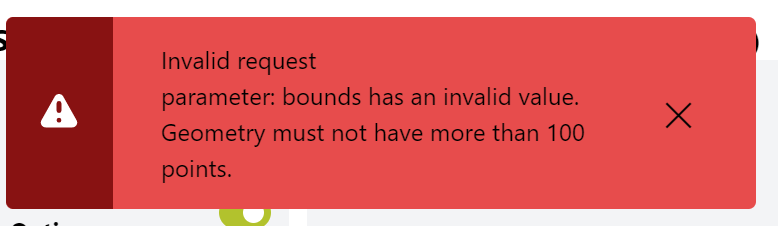
As I understand this error, I might have too many vertices on my polygons (?) however, I can’t “lose” more vertices on my polygon.
Hence, and based on the tutorial I have watched , I would like to ask :
- What is the best way to deal with this error ? Will I have to go polygon by polygon? or are there any additional solutions?
- On the tutorial, The way to access airbus imagery was using the request builder and checking them manually. In my case, on one hand, I want to check which images I purchase, on the other hand, I wonder if there is more “smart” or “efficient” way to do that. I’m used to work with the process API, but seems like it’s not a good idea as I have limited amount of images I can purchase from Airbus. Hence, I would like to ask
if you have additional recommendations for how to tackle this situation - having small polygons with large bbox? Is there any way to automate the process of creating the image collection of airbus without checking images one by one? or at least decrease the manual work.
Thanks ![]()
Reut