Hi William,
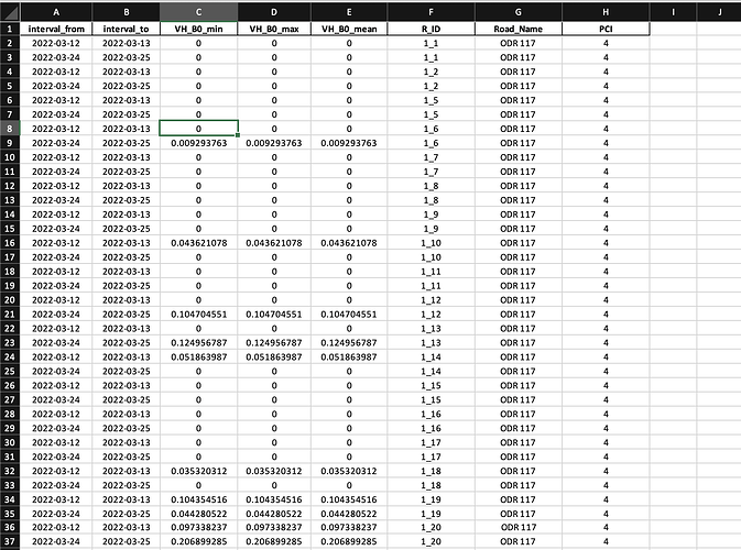
Please have a look at the geojson content here. Looking forward to your response. Understanding these zero values are very crucial now.
{
"type": "FeatureCollection",
"name": "ODR_117_patch_1km_geojson",
"crs": {
"type": "name",
"properties": {
"name": "urn:ogc:def:crs:EPSG::32643"
}
},
"features": [
{
"type": "Feature",
"properties": {
"fid_1": 1.0,
"Id": 29824.0,
"Segment Id": "13560022995077",
"NewSegId": "00004e31-3600-0400-0000-000002b18269",
"Length": 467.86212991836157,
"FRC": 4.0,
"SpeedLimit": 55.0,
"StreetName": null,
"Road_name": "ODR 117\r",
"From": 7.0,
"To": 7.25,
"From_lat": 19.443221,
"From_long": 73.14024397,
"Carriagewa": 3.7,
"PCI": 4
},
"geometry": {
"type": "MultiLineString",
"coordinates": [
[
[
304706.83957613183884,
2150692.730525482445955
],
[
304713.142366190091707,
2150696.36675051599741
],
[
304717.263421228155494,
2150705.093690596520901
],
[
304721.869306270731613,
2150722.305155755486339
],
[
304727.687266324472148,
2150745.819410972762853
],
[
304733.262811375956517,
2150772.727476221974939
],
[
304741.020091447629966,
2150807.392821542453021
],
[
304744.40703947172733,
2150824.540239416994154
],
[
304749.980695497361012,
2150854.372172050643712
],
[
304754.474124071886763,
2150874.299362160731107
],
[
304760.534499127883464,
2150900.237767400220037
],
[
304763.322271653625648,
2150921.449080096557736
],
[
304766.110044179426041,
2150944.720920311752707
],
[
304767.928156696201768,
2150958.659782940521836
],
[
304769.746269213035703,
2150979.628680634312332
],
[
304771.928004233166575,
2150995.870485784485936
],
[
304775.564229266776238,
2151010.415385918691754
],
[
304777.74596428690711,
2151022.778551033232361
],
[
304779.806491805939004,
2151032.353943621274084
],
[
304783.321509338391479,
2151049.322993778157979
],
[
304789.260676893347409,
2151073.140267747920007
],
[
304792.775694425858092,
2151087.685167882591486
],
[
304799.563314488448668,
2151109.684329335577786
],
[
304805.138859539991245,
2151127.623039501253515
],
[
304809.744744582509156,
2151141.683109631296247
]
]
]
}
},
{
"type": "Feature",
"properties": {
"fid_1": 2.0,
"Id": 29824.0,
"Segment Id": "13560022995077",
"NewSegId": "00004e31-3600-0400-0000-000002b18269",
"Length": 467.86212991813562,
"FRC": 4.0,
"SpeedLimit": 55.0,
"StreetName": null,
"Road_name": "ODR 117\r\n",
"From": 6.5,
"To": 7.0,
"From_lat": 19.44734597,
"From_long": 73.141418,
"Carriagewa": 3.7,
"PCI": 5
},
"geometry": {
"type": "MultiLineString",
"coordinates": [
[
[
304809.744744582509156,
2151141.683109631296247
],
[
304813.502177117217798,
2151150.288842210546136
],
[
304818.956514667661395,
2151161.92476231791079
],
[
304826.228964734822512,
2151181.196754996199161
],
[
304834.955904815462418,
2151201.317200182005763
],
[
304841.501109876029659,
2151221.195230366196483
],
[
304844.894919907383155,
2151237.921865520533174
],
[
304849.137182446545921,
2151255.496953182853758
],
[
304854.106689992477186,
2151275.132568364031613
],
[
304860.045857547374908,
2151298.16199357714504
],
[
304863.19725257641403,
2151310.525158690754324
],
[
304866.833477610023692,
2151327.736623849719763
],
[
304871.318155151442625,
2151341.069448973052204
],
[
304877.984567713108845,
2151364.704911691602319
],
[
304884.166150270262733,
2151378.03773681493476
],
[
304889.135657816193998,
2151393.673504458740354
],
[
304893.74154285871191,
2151409.915309608913958
],
[
304900.650370422576088,
2151427.005567267071456
],
[
304909.498518004314974,
2151451.610689993947744
],
[
304923.679795635398477,
2151489.669845345430076
],
[
304938.467110772035085,
2151515.729458086192608
],
[
304949.193974621186499,
2151534.395413258578628
],
[
304959.860234719817527,
2151556.576385963708162
],
[
304967.253892288077623,
2151572.878794864285737
],
[
304969.799249811563641,
2151581.72694244608283
]
]
]
}
}
]
}


