Landsat 8 Collection 2 (Level 1 and Level 2) is now available on Sentinel Hub! Level-1 data from Collection 2 comes with a lot of improvements, which you can read about here, and with additional bands, which you can check in our documentation here. Level-2 science products are generated from Collection 2 Level-1 inputs that meet the <76 degrees Solar Zenith Angle constraint and include the required auxiliary data inputs to generate a scientifically viable product. Learn more about Level-2 from it’s webpage and from our documentation.
To use the levels in Process API, you just need to set the “type” field of the “data” object to “LOTL1” for Level-1 and “LOTL2” for Level-2. To use them in OGC API, configure a layer in your Dashboard by selecting the source dropdown to “Landsat-8 L1 (LOTL1)” for Level-1 and “Landsat-8 L2” for Level-2.
Given that this is fresh, we might have some glitches. In this case, please report to us.
With this release, we are deprecating the old Level-1 (L8L1C) and we recommend you migrate to the new one (LOTL1). Migration should be painless, as we kept the same API expect the utility function decodeLs8Qa to decode Quality Assessment band, as this was not possible because the band has different values in the new collection. Thus we are introducing a new function called decodeL8C2Qa More about deprecation of L8L1C here.
Bands have the original names as in Collection 1. But B10 will be ST_B10, that is, the surface temperature B10 band, right?
Any details on the scaling? Is this mirroring what can be found in the USGS documentation on Collection 2 Level 2?
Maybe first things first: what are the bands that are covered? E.g. is PIXEL_QA band included? In the EObrowser only the optical and the thermal band seems to be available.
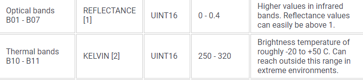
UINT16 in the Source Format column of optical and thermal bands specifies the format of the original data (digital numbers), which we then scale to floating points that represent reflectance and brightness temperature, and that have precision, e.g. in case of the thermal bands it’s.below the 1 degree.
B11 is indeed not present in L2. We mistakenly remove it from L1 documentation and add it to L2 documentation. We will fix it.