Good evening,
I want to ask if it is posible to know how can I have a maximum of size (default size is 256 x 256).
I want to know how can I get maximum please.
(size=[512, 512])
Thanks
Good evening,
I want to ask if it is posible to know how can I have a maximum of size (default size is 256 x 256).
I want to know how can I get maximum please.
(size=[512, 512])
Thanks
the maximum size of the image you can get with Process API is 2500 * 2500 pixel. Note that there’s also a limitation on the size of a pixel, which is 1500 * 1500 meter per pixel.
Good Morning,
I have some few question:
resolucion=5
al=(caja[2]-caja[0])*111.2
an=(caja[3]-caja[1])*111.2
w=int(an/resolucion)
h=int(al/resolucion)
My question is that I don’t know equivalent band that is in planet (I use collection of fincas Bustos).
#!/usr/bin/env python3
“”"
Created on Wed Aug 10 15:15:02 2022
@author: oumnia
“”"
from sentinelhub import SentinelHubRequest, DataCollection, MimeType, CRS, BBox, SHConfig, Geometry
import os
from PIL import Image
import csv
“”"
parametros poligono tienen qu
“”"
def buscarImg(poligono, fechaIni, fechaFin, nombreCarpeta, tipo):
evalscript = “”"
//VERSION=3
function setup() {
return {
input: [{“bands”: [“Blue”, “Green”, “Red”]}],
output: { bands: 3}
}
}
function evaluatePixel(sample) {
return [2.5 * sample.Red / 10000,
2.5 * sample.Green / 10000,
2.5 * sample.Blue / 10000]
}
“”"
caja=obtenerCaja(poligono)
“”"resolucion=5
al=(caja[2]-caja[0])*111.2
an=(caja[3]-caja[1])*111.2
w=int(an/resolucion)
h=int(al/resolucion)
"""


#bbox = BBox(bbox=[-5.7585989, 37.3886755, -5.7565442, 37.3910112], crs=CRS.WGS84)
#geometry = Geometry(geometry={"type":"Polygon","coordinates":[[[-5.7580946,37.3905082],[-5.7579981,37.3903292],[-5.7585989,37.3902355],[-5.7585453,37.3893489],[-5.7583629,37.3886755],[-5.7573811,37.3887778],[-5.7565442,37.3910112],[-5.7580946,37.3905082]]],"type":"Polygon"}, crs=CRS.WGS84)
bbox = BBox(bbox=caja, crs=CRS.WGS84)
geometry = Geometry(geometry={"type":"Polygon","coordinates":poligono,"type":"Polygon"}, crs=CRS.WGS84)

request = SentinelHubRequest(
    data_folder=nombreCarpeta,
    evalscript=evalscript,
    input_data=[
    SentinelHubRequest.input_data(
        data_collection=DataCollection.define_byoc('---'),
        time_interval=('2021-09-30', '2021-10-10'),
    ),
],
    responses=[
        SentinelHubRequest.output_response('default', MimeType.TIFF),
    ],
    bbox=bbox,
    geometry=geometry,
    size=[512, 512],
    config=config
)
return request
The provided script is calculating height and width using a resolution of 5 m. To get the height and width with a resolution of 3 m (highest resolution of PlanetScope), you could use the same script and change the resolution to 3.
The band info of PlanetScope can be found here and here. You could determine the corresponding band by the wavelength. Here’s an example script for NDVI. Note that not all bands required for your interested indices are provided by PlanetScope.
The BYOC collections section in the Bring Your Own COG example demonstrate how to create a new collection using Python scripts.
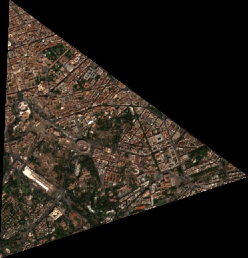
Your script should return an image similar to Fig 1. The pixels outside the specified polygon should be masked. If you are trying to get a TIFF or a Shapefile having a boundary of your polygon, it is not supported unfortunately.
Thanks for answer me.
Thanks
Regards
Could you please rephrase the question? A collection will be automatically created if you don’t specify a collection id when ordering the data (see Import data into existing BYOC collection).
1.1. You can have more than one subscription in the same collection. In general we suggest to have one collection per data type (e.g. PlanetScope, Pleiades, SPOT, WorldView) and reuse it every time you order data of corresponding type.
You order Item Type PSScene4Band so there’s only 4 band in your data. To have 8 band please order Item Type PSScene.
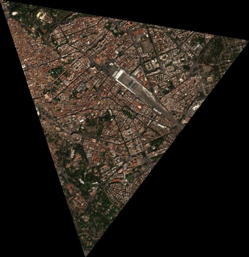
You still get a rectangular image when specifying JPEG and PNG as output format (See the image below), but there’s no data outside the polygon. If this is what you desire in TIFF format, you can simply specify TIFF as output and get a TIFF that has data only inside your polygon.
The easiest way is to reorder the PSScene data. There won’t be extra cost for the same AOI (see here)