We are seriously looking into PlanetScope data for agriculture farm monitoring. While speaking to a few people from the industry we were told that Planet.com images are not ‘calibrated’ so they are difficult to use and we would have trouble with them. Can someone explain what they mean by this and any issues to keep in mind while making use of PlanetScope data?
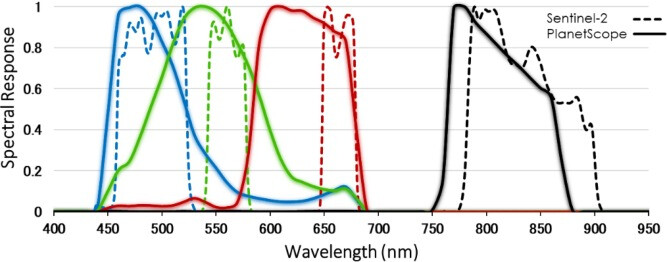
Also, the spectral range of PlanetScope’s RGB seem to be heavily intersecting with each other unlike that of Sentinal-2. PlanetScope is also sensitive to a much wider bands than Sentinal-2.
This also seems like an issue as the channels are wide and not independant.
Lastly, can we get any cloud mask for PlanetScope data like we do with s2cloudless?
Let me start with the last question as it is easier to address. You can use UDM bands to get information about the clouds in very similar way as what you are used to with s2cloudless.
The first issue is more complex, but in short:
We are using PlanetScope data within our Area monitoring activities. It is differnet to Sentinel-2, but we have no trouble.
There are also numerous users of Sentinel Hub, who do the same, on an ongoing (and growing) basis, which makes us think they are happy with the data.
The “not calibrated” comment is probably related to the fact that PlanetScope is a combination of three different constallation and these are indeed somehow different in terms of sensor. That said, you can see in meta-data which constallation the data are coming from and you can simply select to only one. If you are interested in fresh data, there are more than enough Super Doves sensor available to get you decent cadence.
Note that we are planning to publish a blog post on our use of Planet data for Area Monitoring in the next two weeks, it might be interesting for you. Make sure to monitor our Medium channel.
Thanks for your response. We have heard this as an issue, will have to research more on this.
Is the PlanetScope data atmospherically corrected as stated here Atmospheric correction? Else fluctuations may mean atmospheric interference rather than ground changes.
Can you also comment on the spectral band widths mentioned in the first image?
If you choose “analytic_sr” or “analytic_sr_udm2” product bundle you will get the data atmospherically corrected.
I can’t comment on the spectral band width. This is the technical specification, that is given and we cannot really impact it. As mentioned, the data still produce value, which is what is important at the end.