Process API with Planet using two scenes/images

Hi!

We have an AOI where we see two different scenes/images from Planet being used for the same date (2024-02-04):
ede78ffe-94cb-488c-a892-967e69852615

Two questions here:

  • Do you know why for the same day or even for contiguous days Planet raw bands have a significant changes in their values? The same formula is being used for whole AOI but the scene/image on the top shows a chlorophyll index way higher than the one on the bottom. Same thing happens for adjacent days where one would not expect these abrupt changes. I know this is something from Planet, but if you have any ideas on why or how to mitigate this it would be great!
  • For this exact AOI and date we see several scenes/images on Planet and many of them cut through the AOI. There’s only one that contains it completely but instead of using that one, it seems that other two with cuts are being used. In the catalog we can see the complete one. Is there a way to use the correct scene rather than the other two combined when using Stats or Process APIs? Or any reason why SH decides to combine those two instead of using the complete one? Are we missing something about how this works?

This is the one we see in Planet that covers our whole AOI
image

Attaching here the AOI:

{"type":"Polygon","coordinates":[[[-58.586172,-31.186786],[-58.586117,-31.187106],[-58.585905,-31.187474],[-58.585938,-31.187669],[-58.586106,-31.188085],[-58.586206,-31.188586],[-58.586163,-31.188766],[-58.585997,-31.188874],[-58.581718,-31.188831],[-58.580796,-31.189145],[-58.580619,-31.189159],[-58.580255,-31.189068],[-58.579425,-31.18874],[-58.579014,-31.188609],[-58.578317,-31.18831],[-58.57821,-31.188223],[-58.578258,-31.188148],[-58.578824,-31.187626],[-58.579105,-31.187244],[-58.579388,-31.186958],[-58.579567,-31.18657],[-58.57987,-31.186232],[-58.579977,-31.186155],[-58.580729,-31.185849],[-58.58146,-31.185609],[-58.582034,-31.18512],[-58.582231,-31.184991],[-58.582388,-31.1849],[-58.58268,-31.184827],[-58.583015,-31.1846],[-58.583286,-31.184533],[-58.583763,-31.184464],[-58.584562,-31.18452],[-58.584765,-31.184505],[-58.585242,-31.184228],[-58.585479,-31.184167],[-58.585752,-31.18417],[-58.586115,-31.184844],[-58.586166,-31.185091],[-58.586189,-31.18529],[-58.586173,-31.185651],[-58.586098,-31.186218],[-58.586189,-31.186554],[-58.586172,-31.186786]]]}

Thanks in advance for your help!

Hi there!
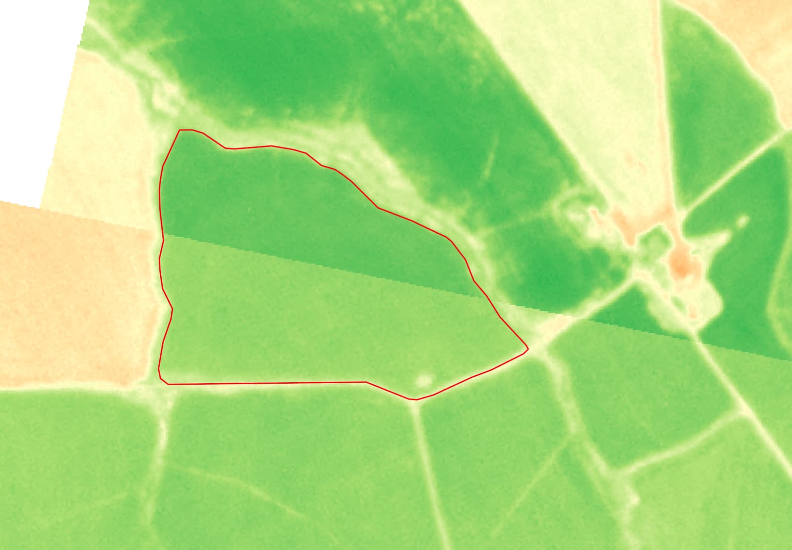
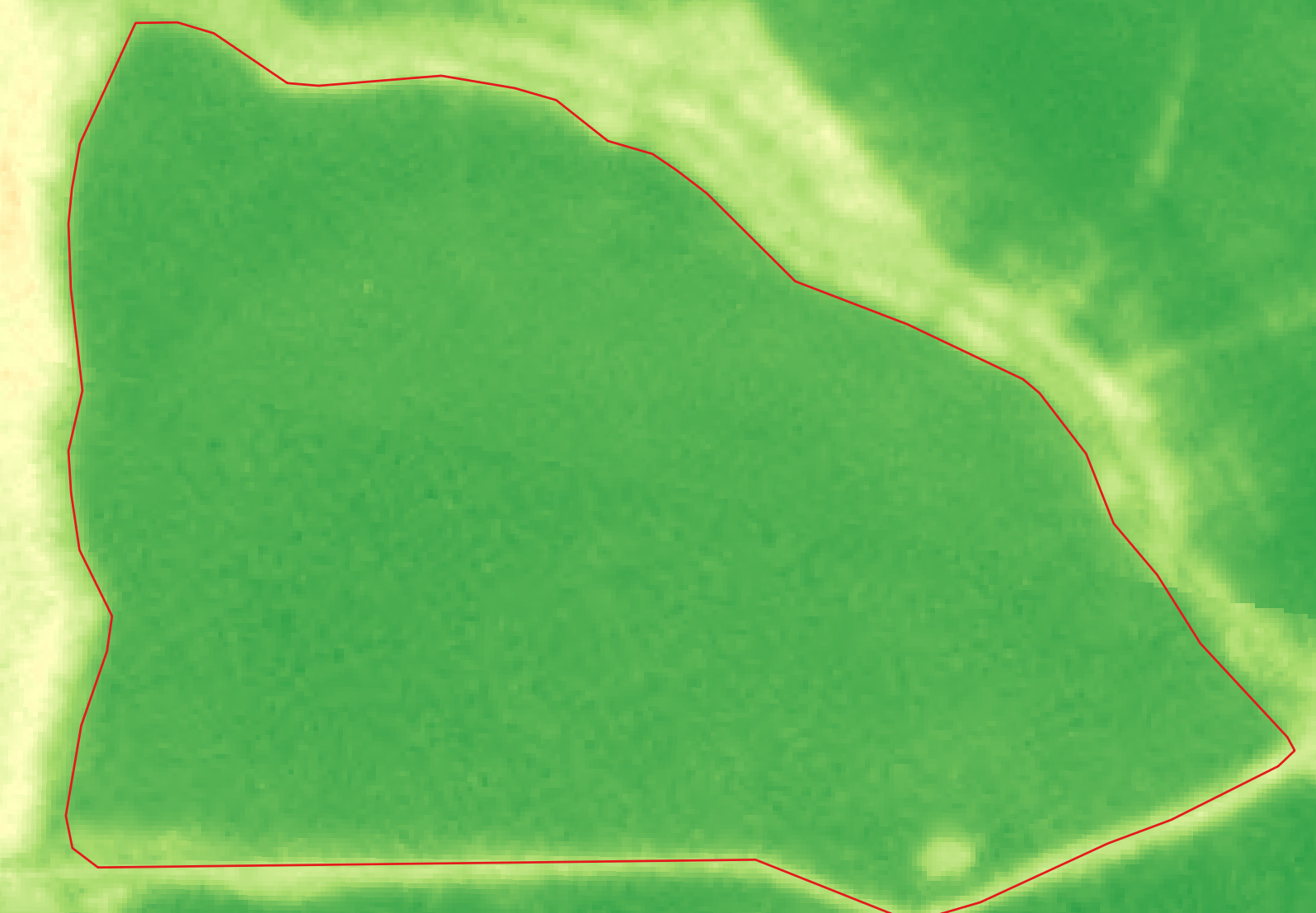
It seems that you are trying to use two PlanetScope scenes 20240204_140524_14_24fc
20240204_131227_69_24d0 that contribute to your AOI. We recommend using scene level normalization that significantly reduces variability between scenes and between generations of PlanetScope satellites while maintaining reasonable radiometric accuracy and compatibility with Sentinel2 data. Please refer to Scene Level Normalization of Planet Dove Imagery

You should incorporate this by using the harmonization tool while placing an order.

The screenshots below show the variability of the NDVI with and without scene level normalization applied.


Regarding part two of your question:
On this specific date (04 Feb 2024), there are 3 PlanetScope scenes that intersect with your AOI. Some of these scenes may cover your AOI fully, and some only partially. You could choose to download the scenes that provide full coverage of your AOI by making use of the coverage polygon in the Catalog API.
Catalog results come with coverage polygon (in GeoJSON), so you can easily make an intersection to see if it is fully within or not. Refer this related thread at Catalog API search for the full geometry

1 Like

Hello!

Thanks for the explanation.
When you say that we should incorporate the harmonization tool when placing an order, do you mean we should add "harmonizeTo": "Sentinel-2" param to the Planet subscription?
Because we apparently have that. Showing as an example part of the payload of the subscription for the AOI we’ve been talking about:

"type": "catalog",
"itemType": "PSScene",
"productBundle": "analytic_8b_sr_udm2",
"harmonizeTo": "Sentinel-2"

Are we missing something here?

For the second topic:

Catalog results come with coverage polygon (in GeoJSON), so you can easily make an intersection to see if it is fully within or not.

We never knew this, it’s super helpful!
As you said, we could grab those geometries and see which one would be better. But, after we choose the scene we would like to use, how do we ask for that specific scene in the stats and process API?
Is it by limiting the time range the only way to do it?

Hi!

  1. Yes, it is essentially harmonize to Sentinel-2.
  2. For part two, you could limit the time range. Here’s some additional documentation and examples pertaining to PlanetScope.
  1. Yes, it is essentially harmonize to Sentinel-2.

But we have our subscriptions with this harmonization tool turned on. As I showed above:

"type": "catalog",
"itemType": "PSScene",
"productBundle": "analytic_8b_sr_udm2",
"harmonizeTo": "Sentinel-2"

This is part of the payload of the subscription for the AOI we’ve been talking about.
How come that we have huge differences between one scene and the other? Is it possible harmonization is not working? Or do we need to configure something else?

This topic was automatically closed 60 days after the last reply. New replies are no longer allowed.