the extension for Sentinel Hub is installed in my QGIS. Creating an image in a timerange from August till now I got back a picture which seemes to have been made from patches of different dates. I was wondering what is the reason for this? Does the system recognise that there are clouds in the area where its snowy and thus takes an image from another date with no clouds?
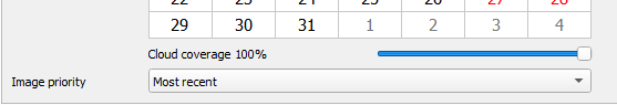
In the QGIS plugin you will see below the calendar a setting for the cloud coverage filter as well as for the image priority. Those 2 together with the selected time range define which image you will get returned. In your case I suspect the snowy image is the most recent that matches for the location the set cloud coverage filter.