At the moment I am trying to get pictures of Austria from 1985 till 2022. For this I want to divide Austria intro multiple squares and get a picture for each individual square. Is there any way to do this? I do not find an option to a) have multiple squares or b) even have an option to copy an existing square to make sure every single one of them is equal.
To process data at national scale the best option we would recommend is our Batch Processing API. The API can process data over Austria in one of the supported tiling grid, and you will have the output as TIFF for each tile delivered to AWS S3 storage. Here is a webinar that help you learn how to process large amounts of satellite data step by step.
An alternative would be the large area utilities available in our sentinelhub python package. With this utilities you can separate a large area into smaller bounding boxes and then make a request for each of them.
You do need an enterprise account for Batch Processing API. The large area utilities is a build-in tool of sentinelhub python package and you don’t need an enterprise account to use it. It is design to allow users to work on a large area with Process API, which does not require an enterprise account.
@chung.horng thanks again
Another question, maybe this is not the right place for it…
Since I only need yearly cloudless mosaics dating back till 1985 I just used google earth pro to get the pictures (since they already mosaic them on a yearly basis for low quality pictures). Do you know if I can just integrate them into the sentinel hub in any way? I am quiet new to working with satellite data and I do not know how to get optimal mosaics with the request builder…
To be more specific I want to look at the change in water bodies over time. I see that sentinel hub has an awesome water body overlay but as far as I understood only dating back to 2020. I want to use this overlay and machine learning to find the change in the already found water bodies. For this I need the yearly pictures.
It is possible to integrate your own data into Sentinel Hub using Bring Your Own Cog API (BYOC). There are some constraints for your data that need to be met before the integration, please read the constraints and follow the example commands to prepare your data for BYOC. We also have a webinar that is worth to take a look.
Regarding the water bodies detection, we have another webinar introducing large-scale mapping with deep learning which could be helpful for you. After that, be sure to check out the associated repository and jupyter notebook that you can find here.
Hi @chung.horng
I am not sure if this is working for me.
I can only get jpg’s from Google Earth Pro and I do not think they meet the constraints…
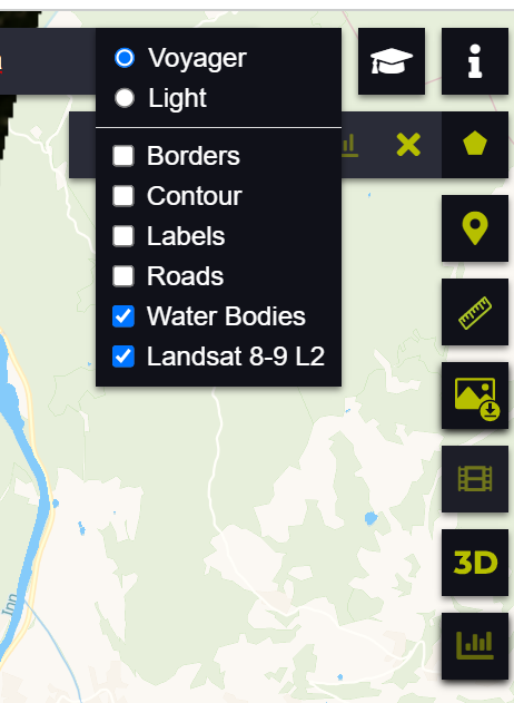
Is there any way to work with the water body overlay? I looked into several water body detections and the one from sentinel hub is by far the best. But I am only able to download either a KMZ but just with the picture or an JPG with the overlay but without any geodata from sentinel hub.
The idea is to get cloudless mosaics for every year and then use a computer vision tool to detect a change between the years for the water bodies from your water body overlay.
But I do not get the same quality of pictures from sentinel hub that I get from google earth pro.
To conclude:
All I need is either a way to get the water body overlay of sentinel hub: Or a way to get the best cloudless yearly picture dating back as far as possible in sentinel hub to then work with the water body overlay directly in sentinel hub.
Thanks for your help!
Is there maybe an online help session sometime? I think it is always easier to explain struggles via talking.
It is easy to get a yearly cloudless mosaic with Sentinel Hub. This blog post should introduce you how to create a cloudless mosaic over your area of interest using Sentinel Hub.
Do you mind specifying to which “water bodies overlay” you’re referring? The global water bodies product is available from 2020, which does not seem to be enough if you want to detect yearly changes.
Yes, just having the overlay is not enough but we are working together with a computer vision company who will detect the changes for us, we just need the pictures going back as far as possible and having the water body overlay together with the pictures would save us a ton of time, since we would only need to detect the changes and not the water bodies itself.
Hi @chung.horng
Two more questions: In the blog post you posted they are using batch API, is there anyway to use Batch API without having an Enterprise account?
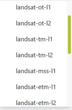
And the other question: I always see the mosaics made with Sentinel. But to get mosaics dating back till 1985 I would need to use Landsat 4,5 and 7 but in the request builder I only have the option for 1 and 2
You need an Enterprise account to use Batch processing API. When making a request for a large area, Batch processing API is actually cheaper than Process API because it results in a multiplication factor of 1/3 (Processing Uint defination).
There is also a workaround to work on a large area with Process API. In the large area utilities example notebook it gives you a step-by-step guide to make requests over a large area using Process API.
I find all of the Landsats in the EO Brower, but not in the request builder. The screenshot above is from the request builder where they are not in the list.
And I cannot build mosaics in the EO Browser, can I?
And to the question with the water body overlay, is there a possibility to download this overlay as a KMZ/TIFF file?
The data you are looking for is included in your screenshot.
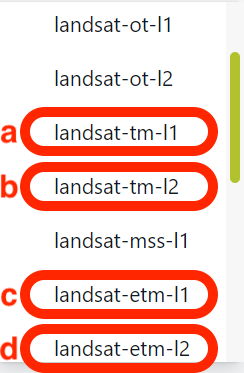
The Landsat 4-5 Level 1 data, which has an identifier of landsat-tm-l1 documented here, is the option a (Fig 1).
The Landsat 4-5 Level 2 data, which has an identifier of landsat-tm-l2 documented here, is the option b (Fig 1).
The Landsat 7 EMT+ Level 1 data, which has an identifier of landsat-etm-l1 documented here, is option c (Fig 1).
The Landsat 7 EMT+ Level 2 data, which has an identifier of landsat-etm-l2 documented here, is option d (Fig 1).
You can definitely download the water bodies data over your area of interest either using Process API or Batch Processing API. If you are interested the water bodies product itself, you can find more information on the water bodies product page.
Hi @chung.horng
Again thanks for the help!
I don’t think that this water bodies product is the same you are using?
I think they are building on Global Surface Water Explorer and also if I use some custom collection like Water Bodies - Sentinel Hub Public Collections I do not find the same water bodies you are finding.
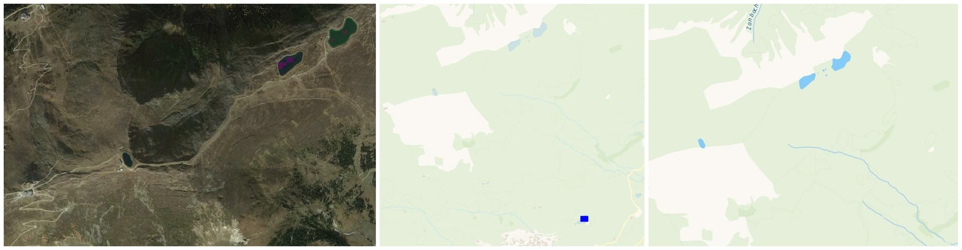
let me show you what I mean:
The first (left) is the global-surface-water
the second the custom collection
and the third (right) the water body overlay that is standard in the EO Browser.
As you can see the overlay the EO Browser is using works the best by far. And I just do not find any information where to get and work with this overlay. Since I can download a KMZ for both the global-surface-water and for the custom collection but not for the EO Browser water body overlay.