If I download a tile with the search functionality and focus on a small area, and for this AOI I download one band through a custom script my values are not identical. I also inspected the difference, and it is not the same for every pixel - so there is not a simple shift value I can apply to the raw data in order to align the valies. Also the downloaded extent differs to the original requested polygon.
Hi @ssh ,
Could you please provide the two requests you made that returned inconsistent pixel values?
Yes, sure!
this is the script
To see the values uncomment the gain 8
And this is the polygon WKT, which is aligned to 10x10 grid of SH:
POLYGON((25.285246 42.302166, 25.29131 42.302257, 25.291232 42.305137, 25.285168 42.305047, 25.285246 42.302166))
If I use Download Image icon | Analytical with resolution 10x10 and UTM projection, it comes shifted
Also if I change the settings for downsampling and upsampling to NN values are changing too slightly.
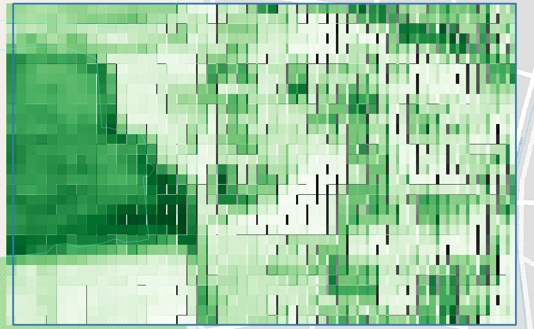
But the values are very different, as u can see from the following image ranging [380,730]:
Hi @ssh ,
The main purpose of EO Browser is visualisation. I would recommend Requests Builder for analytic usage.
Also keep in mind, that Sentinel Hub will prefer keeping the bounding box constraint rather than keeping the resolution constraint. So if you want to get the exact resolution, please align your bounding box so that the extent is cleanly divisible by your resolution.
1 Like
I already showed, that the BBOX is aligned initially to this grid, or at least I think it is aligned. What I did is:
- select my coordinates,
- divide them by 10,
- round the value and multiply by 10.
In this manner I align to the corners of the pixels. Should I align to the central point of the pixel?
You are using a WGS84 BBox. This can never be properly aligned to the UTM Grid. Do try to use Requests Builder and a BBox in UTM coordinates to request data, as Chung suggested.
1 Like
Is there an alternative of Request Builder for downloading processed query in CDSE?
Is there a way to download the result from evalscript for a whole tile rather than constrained to the 2500x2500 size?
For full Sentinel-2 tiles you should use OData API. For additional questions related to Copernicus Data Space Ecosystem, please use their community forum.
Check for processing errors first. Then, verify if there are any known discrepancies in the source data or coordinate systems.
Is there any guide for dummies on a simple single band download using odata - i read about the code - but what are the platforms to generate the code and where do you set it or paste it in order to produce a real download of your result?
Thank you, Grega,
but I know how to do simple download and I use it to verify my results.
My question is about using Odata, I want to download processed data later on, but since I am learning now, I ask simple questions, so I can progress step by step.
My goal is to do some multitemporal analysis and just retrieve the final result. But with request builder I only can get small chunks 2500x2500 rather than whole tiles. So I am searching how to overcome this obstacle now.
Hi Sultana,
I suggest that you look into the APIs available to you on the Copernicus Data Space Ecosystem. It’s correct with Sentinel Hub Process API, you are limited to 2500x2500 pixels due to computing limitations. For large scale processing Batch Processing API is available.
If you have future questions that are related to the Copernicus Data Space Ecosystem, then I kindly direct you to use their community forum, as this is not the appropriate place to ask about OData API, for instance.
1 Like
Thank you, all, for sharing your knowledge!
This topic was automatically closed 60 days after the last reply. New replies are no longer allowed.